


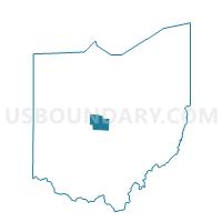
ASHLEY VLG A Voting District, Delaware County, Ohio
About
Outline

Summary
| Unique Area Identifier | 645417 |
| Name | ASHLEY VLG A Voting District |
| County | Delaware County |
| State | Ohio |
| Area (square miles) | 0.38 |
| Land Area (square miles) | 0.38 |
| Water Area (square miles) | 0.00 |
| % of Land Area | 100.00 |
| % of Water Area | 0.00 |
| Latitude of the Internal Point | 40.41054950 |
| Longtitude of the Internal Point | -82.95652250 |
Maps


Graphs
Select a template below for downloading or customizing gragh for ASHLEY VLG A Voting District, Delaware County, Ohio


Neighbors
Neighoring Voting District (by Name) Neighboring Voting District on the Map
- ASHLEY VLG B Voting District, Delaware County, OH
- OXFORD TWP Voting District, Delaware County, OH
- WESTFIELD TWP, Morrow County, OH
Top 10 Neighboring County Subdivision (by Population) Neighboring County Subdivision on the Map
- Ashley village, Delaware County, OH (1,330)
- Westfield township, Morrow County, OH (1,177)
- Oxford township, Delaware County, OH (987)